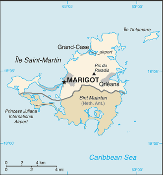
According to the CIA World Fact Book, the island of Saint Martin is the world’s smallest landmass shared by two independent states. A 15 kilometer border separates France’s Saint Martin from the Netherlands’ Sint Maarten, an autonomous area of the Kingdom of the Netherlands. The entire landmass covers only 87 square kilometers, or about half the size of Washington, DC. That’s a mighty small parcel of land to have an international border running across it.

So how did it get that way?
Once again, history and geography interlace with interesting results. Christopher Columbus spotted the island in 1493 during his second voyage to the New World. He named it after St. Marina of Tours, having seen it for the first time on November 11, St. Marina Day. He never set foot on the island and Spain soon focused its attention elsewhere in spite of Columbus’ initial territorial claim.
The Dutch wanted a stopping point between their colonies in North and South America. The French wished to control Caribbean islands in general. Both nations eyed St. Martin, with the Dutch established a settlement first, in 1631.
Spain attacked and captured the Dutch settlement in 1633 as part of a much broader dispute – the Eighty Years’ War – which ended in 1648. With that larger conflict concluded, Spain no longer had a reason to hold onto St. Martin so they left.

France and the Dutch Republic used this as an opportunity to claim Saint Martin and both held firm. Soon they concluded that sharing territory was better than starting a war. So they agreed to split the island in the Treaty of Concordia. Even with an agreement in place, they continued to move the border and argue about it repeatedly until it was finally fixed in 1817.
The separate halves of Saint Martin have coexisted peacefully side-by-side every since.

Leave a Reply