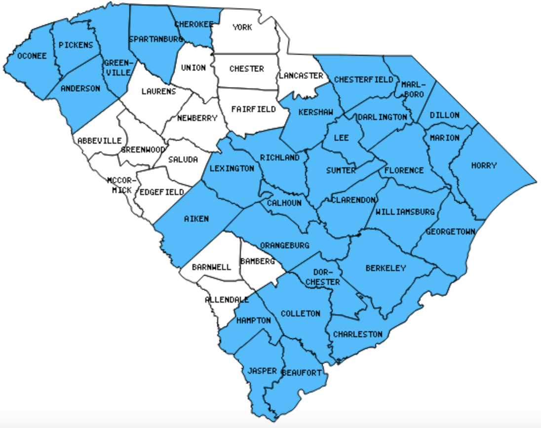
There are 46 Counties in South Carolina – “The Palmetto State“
Also be sure to see my United States County Counting Page for the rest of the states.

I have visited 31 Counties = 67.4% of Counties in South Carolina
Counties visited are colored-in; counties still needing to be visited are blank. Map created using Mob Rule.
Twelve Mile Circle Articles Featuring Places in South Carolina
Markers designate the South Carolina locations featured in Twelve Mile Circle articles.
Counties in South Carolina

Below are the 46 counties in South Carolina. Although infrequent, counties sometimes do change so please let me know if any of this information is out of date and I will update it. Those counties that I have visited are highlighted in Red. Readers can also link to any articles manually in this section if the map isn’t working.
- Abbeville
- Aiken
- Allendale
- Anderson
- Bamberg
- Barnwell
- Beaufort: Beaufort or Badminton; Padding the Count; Beaufort Waterfront, Hunting Island Beach and Marsh; Hunting Island Lighthouse; Beaufort Arsenal; Old Sheldon Church; Robert Smalls Memorial
- Berkeley: Totally Eclipsed; Place Name Palindromes; Stony Landing House; Alligator Loop Trail; CSS David; Wadboo Bridge; Francis Marion’s Tomb; Biggin Church; Old Santee Canal
- Calhoun
- Charleston: Charleston Harbor Lighthouses; Fort Moultrie; Fort Sumter; USS Yorktown at Patriots Point Naval & Maritime Museum; Back to the Lines; Disestablished National Parks; Jasper and Newton; Rice Fields Trail
- Cherokee
- Chester
- Chesterfield
- Clarendon
- Colleton: Pon-Pon Chapel of Ease; Isaac Hayne Tomb
- Darlington
- Dillon: Out of Season; South of the Border; Right Up to the Line
- Dorchester: Givhans Ferry Park; River Bluff Trail; Old Loop Trail; Sawmill Branch Trail; Cypress Methodist Camp Ground
- Edgefield
- Fairfield
- Florence: Odell Venters Landing
- Georgetown
- Greenville: Largest county population in South Carolina (379,616 people in 2000 Census).
- Greenwood: Numerical Place Names
- Hampton
- Horry: Largest county in South Carolina (1,134 square miles).
- Jasper
- Kershaw: DeKalb
- Lancaster: Go South to Go North
- Laurens
- Lee
- Lexington
- Marion: Road to Snow Island
- Marlboro
- McCormick: Smallest county in South Carolina (360 square miles) and smallest county population in South Carolina (9,958 people in 2000 Census).
- Newberry
- Oconee: Fair Play Rest Stop; Shaver Recreation Complex
- Orangeburg: South? Carolina; North AND South; Eutaw Springs Battlefield
- Pickens: Twin Falls; Sassafras Mountain
- Richland
- Saluda
- Spartanburg
- Sumter
- Union
- Williamsburg: Kellahan Park; Indiantown Church
- York: Caro-what?
Quick Facts About South Carolina
- Location: Southeast United States. See map above.
- Size(1): 30,061 square miles. South Carolina is the 40th largest state. The next larger state is Maine and the next smaller state is West Virginia.
- Population(2): 5,084,127 people. South Carolina is the 23rd most populous state. The next more populous state is Minnesota and the next less populous state is Alabama.
- Population Density: 169.1 people per square mile. South Carolina is the 19th most densely populated state. The next more densely populated state is Michigan and the next less densely populated state is Tennessee.
- Bordering States: South Carolina shares a border with 2 states: North Carolina and Georgia.
- Admission to the Union: May 23, 1788. South Carolina was the 8th state admitted to the Union, after Maryland and before New Hampshire.
- Capital: Columbia.
- Highest Point: 3,590 feet at Sassafras Mountain. See SummitPost’s Sassafras Mountain page.
- Lowest Point: Sea Level at the Atlantic Ocean.
- Government website: SC.GOV.
- Official Tourism website: South Carolina tourism.
- Still not enough? See Wikipedia’s South Carolina page.
Sources:
(1) Wikipedia: List of U.S. states and territories by area. Land area only.
(2) Wikipedia: List of states and territories of the United States by population. Estimated population on July 1, 2019.

Leave a Reply