Twelve Mile Circle is always on the lookout for circles for the completely obvious reason. Seeing Circleville, Ohio appearing on a map drew my attention even as I searched for something completely different. My mind raced as I abandoned my earlier effort. I shifted my attention to the pursuit of geographic hoops, bands and rings. Surely, I reasoned, a wonderful circle must live at the beating heart of a town so specifically named in veneration. There it was, an image affixed directly within the town seal.

The Circle
That circle became even more interesting as I delved into its history. Circleville, the town, dated back to the earliest days of the 19th Century. Settlers built it atop a mound complex designed by Native Americans during the Hopewell era. So they repurposed a fifteen hundred or two thousand years old cultural artifact in the process. According to Ohio History Central,
“A circular earthwork consisted of an outer circular wall 1,140 feet in diameter and an inner circular wall with a ditch between them. This double-circle was connected to a square enclosure 908 feet long on each side. In 1820, the walls were five to six feet in height and the ditch was around 15 feet deep. The square had eight openings and each opening was partially blocked by a mound. These mounds were about 40 feet in diameter and four feet in height. At the center of the concentric circles there was a mound, which was about 15 feet in height and about 60 feet in diameter… local residents began building the community of Circleville in 1810 around the large circles. They built the county courthouse on the site of the large central mound and Circle Street surrounded the earthworks.”
Ancient and modern construction blended together in an innovative circular pattern not found elsewhere during that era.
Square the Circle
This is how Circleville appears today.
Most striking, the circle doesn’t exist. There aren’t concentric circular streets, or a courthouse at the center, or a network of streets radiating like spokes from the courthouse. Nothing like that remained. Circleville despite its name evolved into one more town built upon a traditional grid.
It didn’t take long for residents to grow weary of their peculiar circles. The History of Pickaway County (1906) explained the situation.
“It has often been a matter of regret to the citizens of Circleville of the present day that the original conformation of the town was ever changed. The most unique feature about the place from which the town derived its name was obliterated in order that the streets be in checkerboard fashion running at right angles to each other… One of most important reasons advanced for the change was that the open circular space about the Court House presented a very poor appearance as it was the custom of the people from the country to hitch and feed their teams there thus attracting to the place hogs and other domestic animals that were then allowed the freedom of the city.”
From Circle to Grid

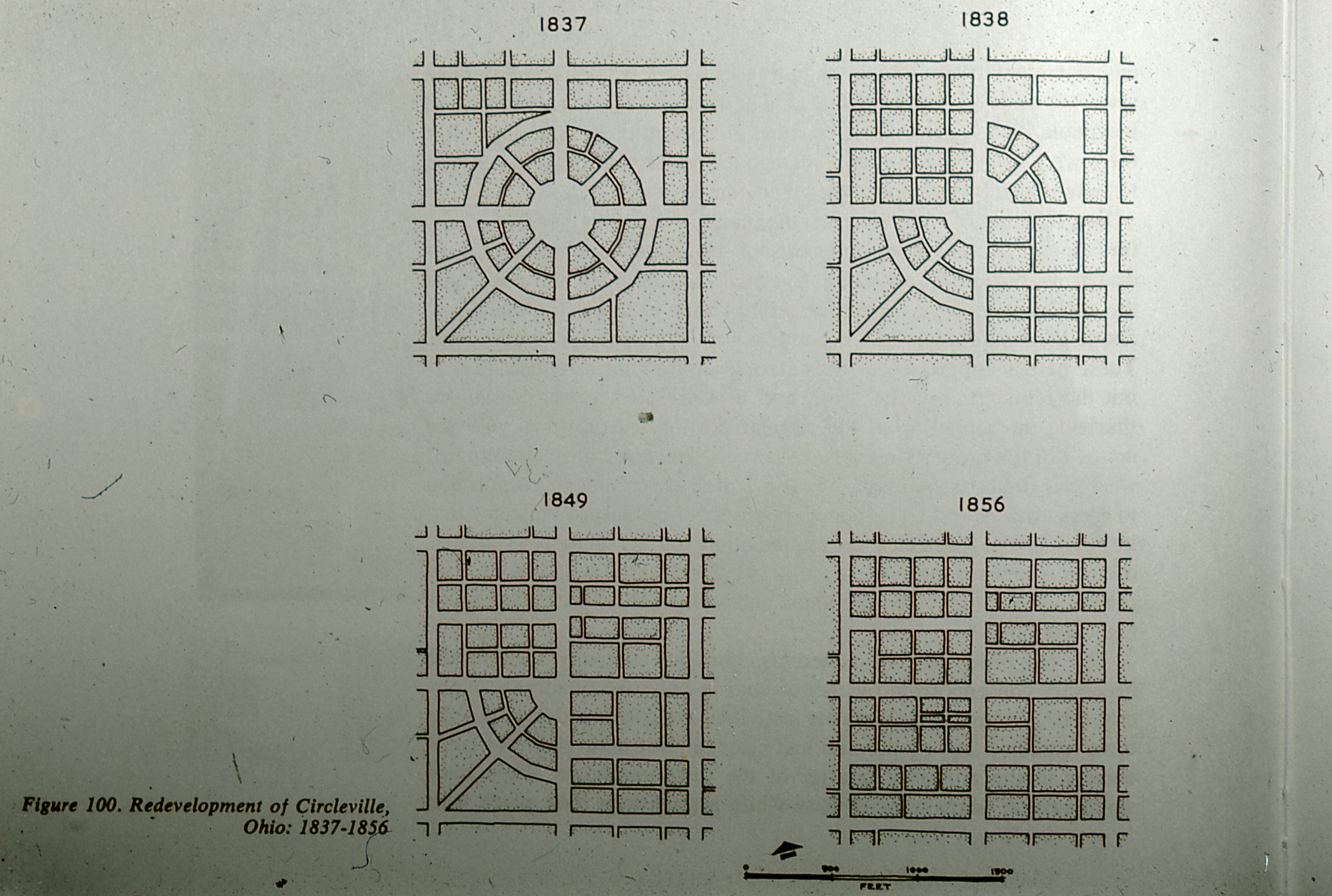
Changing the design wasn’t a simple matter. The General Assembly of Ohio had to pass enabling legislation for any alterations of the town plat. The process also required the consent of each property owner within the great circle. Nonetheless, a few enterprising residents formed the “Circle Squaring Company” with an express intent to square the circle.
They tackled each quadrant separately starting with the southeast quarter in 1837. Next they proceeded to the northwest, then to the northeast and finally to the southwest which waited until 1856. The new design obliterated the circle completely, and with it any remnant of the ancient Hopewell mound. People today would consider than an archeological crime. Back then they considered it one of the earliest examples of Urban Renewal in the United States.
The center of Circleville’s circle, once dominated by the octagonal courthouse atop a Hopewell mound, became just another nondescript intersection. Now it’s Court and Main Streets (map).
Several sources on the Intertubes said that a few old buildings in Circleville still included curved walls that matched the earlier grid. However, those sources all seemed to copy from each other and I couldn’t corroborate the claim. I didn’t find a single example of any legacy curvature after extensive Street View consultation. The squaring process completely obliterated the circle.

Leave a Reply