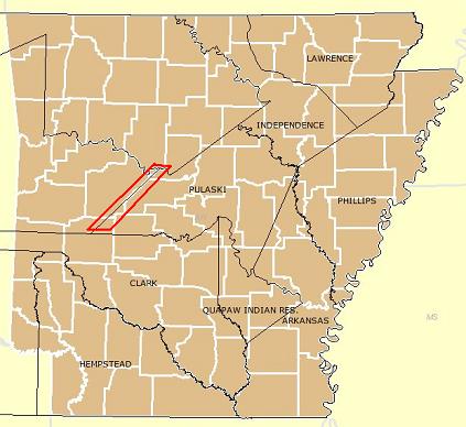
A jagged border exists between Perry and Yell Counties in Arkansas. It comes with fifteen perfectly-aligned steps rising northeasterly like a superhuman staircase stenciled upon the landscape. The path traverses land and lakes alike, in a noticeably precise pattern.
It seemed rather unusual to me. More commonly one would expect to see a border drawn along a straight, diagonal line. Why sequenced steps? The general history of each county provides few clues. Yell County, the one towards the west of the sawtooth, formed on December 5, 1840. They named it for an early governor of Arkansas. It actually included two county seats, Dardanelle (western district) and Danville (eastern district). However, they built the county courthouse in Dardanelle.

Perry County came about thirteen days later, on December 18, 1840. It didn’t include the distinction of dual county seats. Nonetheless, they named it for a more interesting character: Commodore Oliver Hazard Perry, a hero of the War of 1812. Some also remember him as the brother of Commodore Matthew Perry who got credit for opening Japan to the western world in 1854.
Both counties are dry. That means I won’t be stopping in either place for long when I visit them someday in pursuit of my brewery list.
When Did It Arise?

Formation stories for neither county mention a zig-zag border. Oddly, the steps seemed to be a much more recent phenomenon. I consulted a favorite tool, the Arkansas page of the Atlas of Historical County Boundaries. The Newberry Library of Chicago provides this wonderful tool for free. I use this site frequently for another of my other hobbies, genealogy. Knowledge of previous county boundaries helps one look in the right place for relevant government records.
From this, I determined that the sawtooth does have some grounding in a much older, much longer line. Notice that I used the word “line” specifically, as in a single line and not a bunch of them cobbled together to form a staircase. The tool imposes historic county boundaries (black) atop the current boundary structure (white). The line appeared with an adjustment between Crawford County — which extended well into present-day Oklahoma at the time — and Pulaski County, that occurred on October 24, 1821. It comprises the northeastern half of what I’ve enclosed in the red box.
As an aside, Crawford and Pulaski still exist today in greatly diminished forms. Crawford county sits just north of Fort Smith, AR, with its seat in Van Buren (yes, Van Buren! — don’t you love how all these articles intertwine eventually?). Pulaski became the more important one. It serves as the home county for the Arkansas state capital, Little Rock.
The Line Became a Sawtooth
I checked all manner of historic maps of Arkansas online. Then I went through the Newberry tool adjusting various dates. I observed that it remained a single diagonal line throughout much of the Nineteenth Century. It stayed that way even as various other county boundaries changed and solidified elsewhere within Arkansas.
Newberry finally displayed a sawtooth starting on April 8, 1891. I used that to search the the Acts of Arkansas on Google Books. On that date, Act CLXV (“to Define the Lines Between the Counties of Yell and Perry”) came into existence. It also moved a small triangle of southwestern Perry into neighboring Yell.
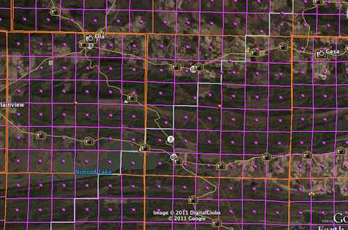
The Act contained numerous references to townships/ranges and sections familiar to those who have ever had to work with the Public Land Survey System (again, very important for genealogists and personal historians). I then used a tool provided by Earth Point to superimpose the existing Arkansas township grid upon the Arkansas county line structure in Google Earth.

Orange lines denote townships/ranges and purple lines denote sections. Notice the classic 36 sections — a mile on each side — within each township. The sawtooth boundary between Perry and Yell appears as a faint whiter line rising diagonally from the southwest corner heading to the northeast. Sure enough, it snaps directly onto the township grid.
Inconclusive
That explained the basis for the weird county boundary but not the reason. Unfortunately, this will require greater research than I could muster using sources easily available to me. I could speculate that it saved the state money because the new county boundaries didn’t need to be resurveyed. Also it would have simplified land ownership and taxation records because township sections would fall entirely within one county or the other. Who knows, maybe even a wealthy or influential individual wanted all of his land to be placed within a specific county. Stranger things have happened.
Whatever the reason, it’s one of the more unusual boundaries I’ve ever seen.

Leave a Reply