I first uncovered a reference to the State of Wayne in a hundred year-old book as I researched the various Van Buren erasures in 19th century Missouri. I noted this fascinating term of art in my records. One never knows when such a thing might come in handy. It gained a prominent place on my ever-growing shelf of tchotchkes that I hoped to examine someday when given the chance.
What’s In a Name?
The name itself captivated me more than anything. It sounded like a joke. State of Wayne? At least the State of Franklin and the Free State of Winston sounded vaguely state-like. They seemed like what someone would name a state given the opportunity. The State of Wayne had more of an appearance of some random guy pulled off the street.
It might as well be the State of Dude, for all of the consideration put into it. I suppose it sounded a bit too much like Wayne’s World. Party on. Excellent. That was also its saving grace. I would have forgotten about it or dismissed it if it hadn’t been so pedestrian.
Not Much Today
There never was an attempt to create a State of Wayne, serious or otherwise. It referenced a particularly large county on the frontier that existed for a time, as parcels quickly formed and organized into more manageable sizes. Only a remnant, a mere artifact, a tiny sliver of the once grand State of Wayne carried the name forward to the present.
The current Wayne County, Missouri has neither notable size nor population. It’s acreage is proportional to other Missouri counties and fewer than 13,000 residents. Greenville, its county seat, has only about 450 residents.
Origin
The so-called State of Wayne, however, once formed a sizable portion of southern Missouri. Campbell’s Gazetteer of Missouri published in 1874 described its dimensions:
“Wayne County was organized from Cape Girardeau, Dec. 11th, 1818, and in 1820 its boundaries were thus defined: north by Gasconade, Washington and Madison Counties, east by Cape Girardeau and New Madrid, south by the territory of Arkansas, and west by the western boundary of Missouri. From her vast extent she was familiarly known as the ‘State of Wayne,’ and since county after county has been taken from her territory, she has been called ‘the Mother of Counties’.”
Most histories tend to note two aspects in particular.
- The original Wayne County was larger than the eastern states of Massachusetts, Connecticut, Rhode Island or Delaware and;
- All or part of 32 separate Missouri counties were once part of Wayne County. There are 115 counties in Missouri today so that’s about a quarter of Missouri counties.
Maps
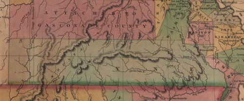
We can surmise from the written description that Wayne occupied a large part of the southern tier of Missouri, and maps from that era tell a similar story.

This is a detail from the 1826 Anthony Finley Map of the State of Missouri And Territory of Arkansas. You may have to look closely but you’ll see W-A-Y-N-E spelled in widely spaced lettering along the bottom of Missouri.
I’ve attempted to produce an eyeball approximating using Google Maps. “Eyeball” means I have sufficient motivation to throw-together a map but I’m too lazy to make it completely accurate. It’s the usual story of my brain: my compulsive attention to detail battling my desire to pursue the path of least resistance. Least resistance won today. Others are welcome to improve upon this product. Then I can link to your image instead of mine.
Context
After I plotted it out I noticed its decent size but it’s hardly all that remarkable. There are plenty of counties out west today that are considerably larger, not to mention many of Alaska’s boroughs. Then I stood back and put it into its larger historical context. This was the first quarter of the 19th Century. It wasn’t long after the Louisiana Purchase. There wasn’t a Texas annexation, a Mexican cession, or an Oregon Country yet. This was indeed part of the western frontier of the United States for its time.
Wayne County would have seemed monumentally huge when compared to the settlers’ frame of reference; the small eastern states of their ancestors with their diminutive counties and townships.
Why choose a pedestrian name like Wayne, though? It was named for Anthony Wayne, an American general in the Revolutionary War. He was a bold and tenacious leader with a fiery temper, leading to a popular nickname: “Mad Anthony” Wayne. Now that’s more like it.

Leave a Reply