I noticed an anomaly when I researched Kansas Mountain Time for an article last January. Very little of Kansas remains in Mountain Time. Also, I suspect the entire state will flip eventually to Central Time. That hasn’t happened yet and the anomaly will remain in place until that occurs.
A Three-Sided Occurrence
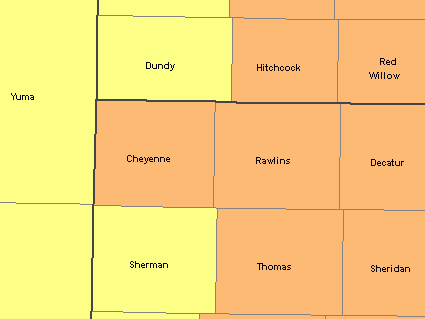
Notice the far northwestern corner of Kansas, just north of the Mountain Time counties. That’s Cheyenne County. Cheyenne switched to Central Time in approximately 1955 according to the Statoids website. Meanwhile, western Nebraska observes Mountain Time as does all of Colorado. That created a situation where Mountain time surrounds Cheyenne County on three sides. Drive east from Cheyenne and one will remain in Central Time. However, drive north, south or west, and one will enter Mountain Time upon passing the county border.

This becomes more obvious in the image I created in the National Atlas of the United States’ Map Maker. Sadly this tool no longer exists. But when it did it used to let users create maps with time zones and county boundaries.
I considered whether this might be an unusual situation — a rare instance of time zone herniation of a county completely protruding into its neighbors — or whether it was entirely more common. I went through the time/county overlay in Map Maker and found only one other example, well, four-fifths of an example actually. Cheyenne County is either unique or nearly unique, with a different time zone found completely on three sides.
The kind-of, maybe, sorta instance

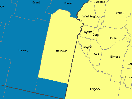
This is Malheur County, Oregon. I’ve mentioned Malheur before. It sits in a unique corner of Oregon in Mountain Time. It also contributes to the trick question about an Atlantic state and a Pacific state only one hour apart (and on the same time for a single hour each year when the nation turns the clock back in autumn). However, take a closer look and it’s apparently that a small sliver of Malheur’s southern end observes Pacific Time just like the rest of Oregon.
Title 49, Section 71.9 of the US Code of Federal Regulations defines the separation: “thence southerly along the west line of Malheur County to the southwest corner of T. 35 S., R. 37 E.; thence east to the Idaho-Oregon boundary“. It’s a matter of drawing a line along the designated township and range boundary which corresponds to a latitude at approximately 42.45° north. It’s literally in the middle of nowhere (map).
Most of Malheur observes Mountain Time because it’s so far removed from Oregon’s cities that it’s more aligned economically with places in Idaho. That doesn’t explain the lower one-fifth, though. I looked a little closer.

Actually the southern portion accommodates residents of McDermitt, a town split by two states. The majority of McDermitt falls on the Nevada side of the border. Nevada follows Pacific Time. Thus it makes sense for this small corner of Malheur to follow Pacific Time too. It makes even more sense when one considers that 75% of the population is associated with the Fort McDermitt Paiute and Shoshone Tribe.
Do we count Malheur as a second example in spite of its split personality? Or do we consider Cheyenne a truly unique occurrence?
Random Unrelated Item
This nondescript grass path in a generic housing development leads to the Historic Tucker Family Cemetery, which is the oldest African American cemetery in the former English colonies of North America. It dates back to the arrival of slavery in the Jamestown colony in 1619. Local press accounts described its long neglect and reported on recent restoration efforts. It’s shocking how a place of such historic significance could have fallen into such disrepair for the past half-century. History lurks everywhere. Even in the suburbs.

Leave a Reply