An arc-shaped portion of the border between Delaware and Pennsylvania serves as the most visible manifestation of the so-called Twelve Mile Circle, as noted in the previous entry. However other impacts can also be discerned. The oddity also effects the Delaware – New Jersey boundary, albeit less visibly.
Refer back to the map again and let’s reacquaint ourselves with the layout:

A Complicated River Border
Imagine in your mind’s eye a complete circle and notice where it crosses the Delaware River on the north and on the south. Delaware’s territory extends right up to the mean low tide mark on the eastern riverbank within the circle. In contrast, Delaware and New Jersey split ownership of the river using the thalweg method outside of the circle.
I have a previous entry that describes various methods of splitting river borders so go there if you’d like a more detailed explanation. As unusual as it sounds, the two states have a different basis for dividing their river boundary depending on whether one is inside or outside of the 12-mile circle.
Other than being a geographic curiosity and a great trivia question, does it really matter? Indeed it does, and it comes with a lot of implications. First, Delaware owns all of river islands within the circle.
Pea Patch Island

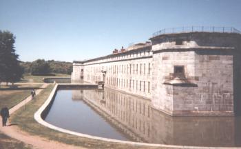
Pea Patch Island is one of those islands and today it’s the site of Fort Delaware State Park (map). I have an interest in coastal defenses and fortification and I was fortunate enough to visit here a few years ago. Pea Patch Island emerged as a mud bank in the 18th Century. By the early 19th it had grown large enough for the U.S. Military to construct a fort on the site. It was designed to help defend the river and the approach to important commercial centers such as Wilmington and Philadelphia.
It never saw action but it did serve as a prison for captured Confederate soldiers during the Civil War. Pea Patch Island increased further in size when the Army Corps of Engineers dredged a shipping channel nearby and used it as a convenient dumping spot for fill dirt. More germane to our topic though — and since Pea Patch Island falls within the circle — all 288 acres automatically belong to Delaware.
Practical Exclaves
There are even portions of Delaware on the “wrong” side of the river, accessible by land only from New Jersey. One such instance happens here:
Notice where the border cleaves through the National Wildlife Refuge at Finns Point. The Delaware River silted-in was backfilled (perhaps by the Corps of Engineers) along this curve after the establishment of the original boundary. Today it provides vital wetlands for migratory birds within an otherwise developed area.
Logically it would seem that the entirety of Finns Point would belong to New Jersey. After all, the boundary should have been the mean low tide mark. However, as we’ve seen time and again, a state will not willingly cede territory just because a river changes (Carter Lake, Iowa and Kaskaskia, Illinois being two fairly prominent examples). Therefore it remains part of Delaware. As an interesting tangent for those of you who collect state extremities, take note that Finns Point also serves as the westernmost spot in New Jersey so strange geography abounds here.
The place where the 12 Mile Circle crosses the Delaware River on the south side presents another interesting anomaly:
The arc departs from the low tide mark along the New Jersey shore and once again becomes a state border out to the river’s thalweg, clipping through the tip of a small peninsula which falls into Delaware territory. Good luck trying to get to that spot by land, though. Just to the south (and viewable in the satellite image) are the Salem and Hope Creek nuclear power plants. The only road that seems to head towards the peninsula goes right through those sensitive, high-security areas. Boating might be a better option but my guess is that it might still be within a sensitive area. Tread lightly here.
Disputes
Amazingly the border still causes friction between the two states. In the United States, the Supreme Court has original jurisdiction over disputes between individual states, and there have been three separate cases dealing with the border in recent decades, all titled New Jersey v. Delaware. All three Supreme Court decisions upheld the existing boundary.
The latest case happened quite recently, on March 31, 2008. The energy company BP wished to construct a liquefied natural gas pipeline and loading facility within the Delaware River. It would terminate at a storage and processing plant on the New Jersey side. Delaware denied BP’s petition as a violation of its Coastal Zone Act because the project would require dredging of Delaware land below the river. New Jersey stood to profit handsomely from the facility so they field suit against Delaware. Delaware prevailed in a 6-2 decision. Thus the border still stands unchanged in its current configuration. Wikipedia discusses this in much more detail.
We’re likely to have this wacky river boundary — with different ownership rules inside and outside the circle — for some time to come.

Leave a Reply