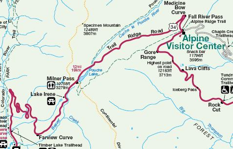
As covered in the prior post, Trail Ridge Road reaches stratospheric elevations. It climbs to become the highest continuous highway in the United States. There it cuts straight through the splendor of Rocky Mountain National Park.
Visitors scaling the summit from Estes Park, Colorado encounter another noteworthy feature along this remarkable road. This happens after they pass the highpoint and the Alpine Visitor Center, heading downhill.
A Continent Divided
At Milner Pass, the highway crosses over the Continental Divide.

In truth there are several continental divides in North America. Some are specific to the United States and some to Canada, with others are shared in common. The Great Divide offers the prime example, a physical contour separating east from west. Water on the eastern side will flow either to the Gulf of Mexico or the Atlantic Ocean. Meanwhile, water on the western side will flow to the Pacific Ocean. When people use the term “Continental Divide” without qualifiers it generally means the Great Divide. That’s the famous line crossed by Trail Ridge Road at an altitude above 10,000 feet.
A Marker

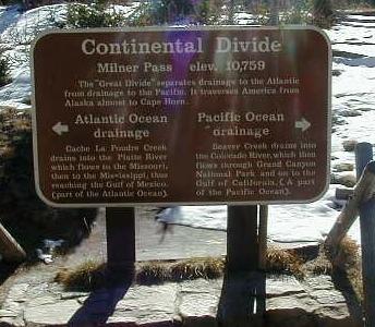
Continental Divide
Milner Pass elev. 10,759
The “Great Divide” separates drainage to the Atlantic from drainage to the Pacific. It traverses America from Alaska almost to Cape Horn.
Atlantic Ocean drainage [arrow pointing left]
Cache La Poudre Creek drains into the Platte River which flows to the Missouri, then to the Mississippi, thus reaching the Gulf of Mexico (part of the Atlantic Ocean).
Pacific Ocean drainage [arrow pointing right]
Beaver Creek drains into the Colorado River, which then flows through Grand Canyon National Park and on to the Gulf of California (A part of the Pacific Ocean).
So there are two remarkable geographic features in a short stretch along Trail Ridge Road: the highest point of contiguous highway in the United States; and the boundary that marks the Great Divide. Along with that comes some of the most incredible Rocky Mountain scenery imaginable, worth a journey all on its own.

Leave a Reply