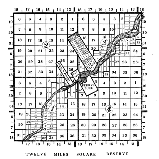
Twelve Mile Circle meets a Twelve Mile Square. I thought I’d found just about every subject with a Twelve Mile theme, every town, every lake, every building, even every bottle. Apparently I missed one, although in my own defense I’ll note that it was a different shape. It formed a square rather than a circle: The Twelve Mile Square Reservation (or Reserve).
The story behind the square began long before such a shape existed at the spot in question, now superimposed upon modern-day Perrysburg, Ohio. The Great Lakes provided trade routes deep into the North American interior for colonial-era powers, France and Great Britain. Rivers and their watersheds carried trappers and traders even farther inland. The Maumee River, for example drained an area now in northwestern Ohio and part of Indiana. This included modern-day Toledo to Fort Wayne, before dumping into the far western corner of Lake Erie.
However, back then, it was a wilderness deep within the natural domain of Native Americans. French interests in the area extended as far back as the 17th Century. They were more interested in trade than settlement. Likewise the French maintained generally peaceful relationships with the various tribes for decades. Britain, and later the nascent United States, pursued territory aggressively. This created friction with the original inhabitants. Thus the newcomers constructed forts at strategic locations to protect their settlers.
The Americans Arrive
Britain ceded the Northwest Territory — lands northwest of the Ohio River, roughly the central and western Great Lakes states of the current U.S — to the United States in the Treaty of Paris, which ended the American Revolutionary War. Even so, Britain continued to build and occupy fortifications within these frontier lands after the war.
Article 5 of the treaty specified that the U.S was supposed to “… provide for the restitution of all estates, rights, and properties, which have been confiscated belonging to real British subjects.” The United States, Britain claimed, did not uphold its obligation. Therefore the British would not relinquish its frontier territory.
The British interpretation provided a convenient subtext to maintain lucrative trading partnerships. It also allowed them to stir-up trouble behind the scenes between the local Wyandot, Shawnee, Delaware and Miami peoples and the American settlers who continued to migrate increasingly farther away from the Atlantic seaboard.
A confederation of miscellaneous Native American tribes coalesced around a common objective. They all wanted to halt American expansion onto their lands. Thus began a decade of intermittent back-and-forth violence and warfare known as the Northwest Indian War. It culminated in the Battle of Fallen Timbers (1794) and the Treaty of Greenville (1795).
What about the Twelve Mile Square Reservation? I’m getting there. Be patient.
The British constructed Fort Miami (Miamis) along the Maumee River as the war drew to its conclusion. They designed it to aid Native resistance and block advancing U.S. forces. It accomplished neither. U.S. commander Gen. “Mad” Anthony Wayne defeated the Western Confederacy decisively at Fallen Timbers, a few miles downriver from Fort Miami.
Creation of the Twelve Mile Square Reservation
In the Treaty of Greenville, the U.S. pushed tribes of the Western Confederacy even farther inland after their defeat. It established what became known as the Greenville Treaty Line that opened much of southern Ohio to American settlement. The Confederacy also ceded several random parcels of land. This included one split by the Maumee River near its confluence with Lake Erie. It resulted in a small enclave well north of the treaty line. As described in Article 3, section 8:
“And for the same considerations, and as an evidence of the returning friendship of the said Indian tribes, of their confidence in the United States, and desire to provide for their accommodations, and for that convenient intercourse which will be beneficial to both parties, the said Indian tribes do also cede to the United States the following pieces of land, to wit: … One piece twelve miles square, at the British fort on the Miami of the lake, at the foot of the rapids.”
The Twelve Mile Square Reservation included the land beneath Fort Miami. The exact reasoning remains unclear since Britain wasn’t a Greenville signatory and the treaty didn’t apply to them. Various theories exist. Perhaps the U.S. designed it to cut off Native Americans from British supplies. Or maybe they simply wanted to establish a claim on an important river corridor.
The British Depart
British forces left Fort Miami not long thereafter as a result of a different treaty, the Jay Treaty. Article 2 stated:
“His Majesty will withdraw all His Troops and Garrisons from all Posts and Places within the Boundary Lines assigned by the Treaty of Peace to the United States. This Evacuation shall take place on or before the first Day of June One thousand seven hundred and ninety six…”
This left the Twelve Mile Square free of Native Americans and free of British troops, and available for unchallenged American settlement.

The Twelve Mile Square Reservation was surveyed independently from any other area of Ohio. It stands out distinctly from other survey areas even today, a small legacy of a forgotten war.

Leave a Reply