Ushuaia

I can find good geo-topics practically anywhere. Often I derive inspiration from anonymous Twelve Mile Circle visitors who sprinkle digital trails behind them as they travel along. Every one of us leaves fingerprints behind whenever we tunnel through the Intertubes.

It’s innocuous for the most part. Generally we don’t think much about it as we jump from one site to another. However, it’s all there and it’s all available. I can’t and don’t use any of it to identify individuals (nor do I want to). Even so, I do use it to generate plenty of great story ideas.

One trekker arrived from Ushuaia, Argentina looking for information on New Zealand Ferries. That’s what I believe, anyway. The incoming IP address geolocated to that rare spot. This person thus became the southernmost visitor to my website totally unbeknownst to them. So that’s likely an honor that will extend until someone from Antarctica calls.


Indeed, Very Far South

Ushuaia sits at 54.8° south of the equator. There aren’t many places of significance further south than Ushuaia.

Ping around the Internet for awhile and examine the situation. It won’t take long to find a variety of sources that consider Ushuaia to be the southernmost city in the world. “City” is such a subjective word. Does 60,000 people make it a city? Punta Arenas in Chile has double that population a little further north. Puerto Williams has a couple thousand people a bit further south. Which one is the southernmost city?

Argentina and Chile also have a history of one-upmanship at the continental tip. There they jockey for control of trading routes, tourism and access to Antarctica. I guess Ushuaia has as good a claim to being the southernmost city as the others. Really though, it’s more for bragging rights than anything else.


Why Does It Exist?
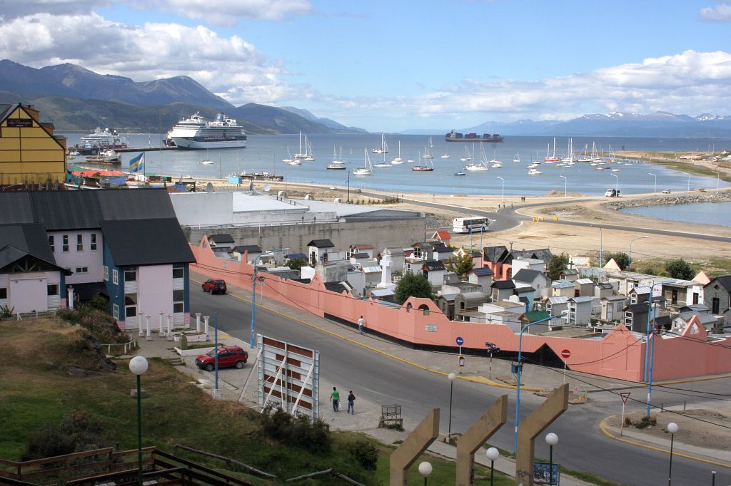
Ushuaia. Photo by Médéric; (CC BY-NC-ND 2.0)

In fact the strategic location of Tierra del Fuego and the geopolitical situation with Chile led to the founding of Ushuaia in the first place. It doesn’t have Sixteenth Century roots like many other towns and cities in Argentina, not at all. Rather Ushuaia dates back only to the 1890’s when it started as a penal colony. Those early convicts literally built their own prison and then a town around it.

Ushuaia provided a remote, confined location for the more troublesome members of society. Additionally it let Argentina assert sovereignty over its southernmost domain. That sounds a lot like the Australian model and indeed it took inspiration from that source.


Getting There

Ushuaia. Photo by Tak; (CC BY-NC-ND 2.0)

Ushuaia gazes upon the Beagle Channel, with Chile to the south and west. It anchors Argentina’s triangular corner on the Island of Tierra del Fuego. Thus, it sits isolated and detached from the rest of the nation.

Airlines and ships provide the most direct access to and from the Argentine mainland. It is also possible to arrive by automobile. However, this journey requires crossing into Chilean territory and taking a ferry across the Strait of Magellan. In theory one should also be able to arrive by bus. That would require several distinct transfers and lots of time so pack some patience.

Trains do not reach this far south. But the city does have an antique 8 kilometre narrow-gauge steam railroad called the End of the World Train (Ferrocarril Austral Fueguino) into the Tierra del Fuego National Park. It serves as a major tourist attraction. Officials designed it originally to carry timber into Ushuaia as the prisoners built the town. Today many consider this the world’s southernmost railroad although it’s self-contained and it has no outlet to the outside world.


Thanks Ushuaia!

I didn’t know anything about Ushuaia until I noticed that small dot on my website access map in Google Analytics. This sounds like another great place to visit. Maybe I should add it to my every-growing list of towns that I someday want to see in person.

Do you know of a peculiar place or location you’d like me to feature on Twelve Mile Circle? Maybe your home town? Please let me know in the comments below or in a separate email message. Don’t let me know why you believe it’s a geo-oddity though. I’ll figure that out on my own and the answer may be completely different than what you expected. Learning is part of the fun.

Comments

6 responses to “Ushuaia”

  1. Jean-François Bouchard Avatar
    Jean-François Bouchard

    There are bus services to Ushuaia, some from Punta Arenas (via Porvenir), but mostly from the Argentine town of Rio Gallegos on the mainland. The latter are Argentine buses, with Argentine passengers, traveling between Argentine towns, but it involves crossing the Chile-Argentina border twice, a very time-consuming masquerade. The very concept of “transit” does not seem to weigh against national prides ! It takes about 14 hours to travel the distance, including 5-7 hours of waits and border checks, a ferry crossing of the Straits of Magellan, and the use of an especially bad stretch of road in the Chilean territory.
    Thanks for your excellent site
    JFB, Québec QC Canada

  2. Katy Avatar
    Katy

    How about a few words on St. John’s in Newfoundland, Canada? Seems to be a nice little town (or city?).

    1. Twelve Mile Circle Avatar

      Thanks for the suggestion, Katy. I’ll have to check it out and see what I can come up with. In the meantime, feel free to ponder the (nearby) Mount Pearl Mystery! 🙂

  3. Matthew Avatar

    Great post. Ushuaia is the southern terminus of the Pan American Highway, which runs from there to Prudhoe Bay, AK, almost without a break (The Darién Gap separates Panama from Columbia and requires some form of transportation other than motor vehicle). Aside from that gap, this is apparently one of the longest roads on the planet. I think I’d like to drive it someday.

  4. Guy Avatar
    Guy

    I visited Ushuaia for a few days back in 1993. I took the bus/ferry route from Punta Arenas, not through Porvenir but through Cerro Sombrero and the eponymously named Chilean/Argentine border towns of San Sebastián. It took me a while – I don’t remember when I left Punta Arenas, but I do remember arriving in Ushuaia late in the evening. There wasn’t much to do there at that time, apart from visiting the aptly named Museo del Fin del Mundo (Museum of the End of the World). Hikers could explore the surrounding mountains. If you are ever in the area (and if you like hiking) I would recommend visiting the stunning Torres del Paine National Park north of Puerto Natales in Chile, though.

    Yes, I do know of some peculiar places I’d like to see covered on Twelve Mile Circle:
    – A location I’d like to visit is Surveyor General’s Corner in Australia. Do you know what’s so peculiar about it?
    – While we’re in Australia I’d also like to know if you can find out what’s special about the Northern Territory/Queensland border and the Victoria/South Australia border. And please let me know if you ever make it to the point where the western borders of New South Wales and Victoria meet! Last one: do you know where the shortest border between two Australian states/territories is located?
    – Maybe you can also find something peculiar about the cities I lived in during the last twenty years: Ghent, Belgium / Tirana, Albania / Mechelen, Belgium / Christchurch, New Zealand?

  5. Lincoln Ho Avatar

    Every province in Canada has a different population definition of city. Alberta has a definition of over 10000 people, but the town still needs to apply for a city status. Sherwood Park in metro Edmonton is considered the world’s largest hamlet even though it has a population of over 50,000. That’s because it’s unincorporated and its governing body is the county of Strathcona.

    In Ontario, the same 10000 mark allows a town to apply for city status. Markham is the largest ‘town’ in Canada at over 260,000 people. And Dryden has 8100 people, but still a city, because it was incorporated when it surpassed the 10000.

    In Quebec, there are no designations between cities or towns. All municipalities are villes.

    In Saskatchewan and British Columbia, cities are considered over 5000 in population.

    Statistically, Statistics Canada counts CMAs (Census Metropolitan Areas) in its definition. It means that if an area has a population over 100,000 where the area covered contains people that travel daily from one distance to another for work, then it is a metropolitan area.
    The boundaries of the CMA changes with every census depending on whether someone has to make a trip to work in Edmonton daily. It used to stretch as far was Vegreville in the East (95km) and Evansburg in the West (96km) by that definition, and that’s how Edmonton’s metro population got its so-called 1 million inhabitants, when the city population is just 730,000.

    So rabbit trail aside, by Canadian provincial definitions, Ushuaia is a city, but not by the CMA.

Leave a Reply

Your email address will not be published. Required fields are marked *

Latest Comments

  1. Does anyone have actual music to the song – Tanaha ,Timpson. Bobo and Blair ?? It was recorded by Tex…

  2. I am a grandchild of Jury and David Adams of BoBo Tx Shelby County we still have the family home…