Reader “HH” brought an interesting situation outside of Boston, Massachusetts, to my attention this week. He discovered this many years ago and has been wondering about it every since. On the surface it doesn’t seem like much, just a ride along U.S. Route 20. It has a bit of historic importance in its own right, forming a part of the old Boston Post Road. Hold on though, it soon become an addictive geo-oddity.
The stretch between Boston and Springfield, the highlighted section included, formed a part of the Upper Post Road specifically. It was based on yet an earlier trail called the Old Connecticut Path. Prior to that, Native Americans used it long before the arrival of the first colonists.
People have followed this route for many centuries and it’s ancient by New World standards. The early European settlers adopted this existing path as they pushed westward from the coast. They formed historic colonial towns along the way that still exist today.
Towns in New England
That’s all fascinating and I’d love to travel along here in person some day. However, that’s not what prompted HH to highlight it.
You might have noticed something peculiar if you followed the line I drew. The title of the article gives the answer away but it may have escaped your attention. The pattern doesn’t become glaringly obvious until it’s compared against a map of minor civil divisions. None of the interactive map sites on the Intertubes includes these divisions as far as I know. Google doesn’t even handle county boundaries well for the United States, much less the next level further down. So it’s not going to be helpful for this exercise.
Minor civil divisions go by several names. Massachusetts and some of the other New England states call them towns. I’m more familiar with the Midwestern variant, the Township. Other places may call them Precincts, and in still others the concept simply does not exist at all. It’s rather confusing. Politically they can range anywhere from forming the basis of a strong, fundamental unit of local government to representing nothing at all depending on the State.

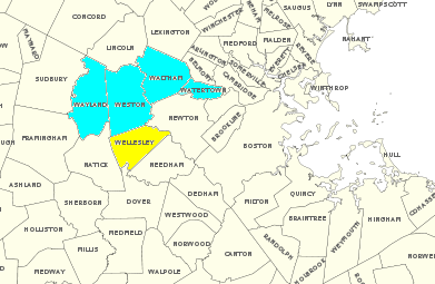
Massachusetts has more than three hundred towns and cities. Together, they divide the state and its counties into a complex mosaic of tiny slices. Wikipedia has a great public domain map of this, and I’ve created the image above from that source.
A Pattern Appears in Massachusetts
That’s a lot of background material. Even so if felt it would provide proper context to help understanding the remarkable nature of what HH discovered. By driving solely along U.S. Route 20, a traveler will follow the historic main streets of four sequential, contiguous towns starting with the letter W — Watertown, Waltham, Weston, and Wayland — until Sudbury breaks the pattern. That’s a distance of only about ten miles so it demonstrates the diminutive size of these minor divisions.
Travel away from Route 20 south of Weston and there’s actually a fifth contiguous W town, Wellesley.
HH wondered, and I didn’t know, if there are any other places that can equal or better that pattern. I conducted some very cursory checking of map resources available to me and I couldn’t find anything similar. I wanted to throw the question out to the larger Twelve Mile Circle audience. What do you know or what can you uncover with a little checking.
I’d also like to broaden the search as well. It doesn’t have to be the United States and it doesn’t have to focus on a single letter of the alphabet. I’m looking for unusual patterns, if not the same letter of the alphabet then maybe a contiguous sequence of letters (e.g., a, b, c, d, e) or the same number of letters, or simply random weirdness in general. The U.S. Census Bureau provides maps of minor civil divisions in the United States to help get you started. I’m sure other nations provide similar resources within their borders.
I’ll start looking closer at this question between articles and during my spare time. I hope you will too. Maybe this could become a recurring topic if we start to find some interesting patterns.
Thanks HH.

Leave a Reply