West Coast Sunrises over Water

We’ve had fun watching the comments posted on my recent entry, East Coast Sunsets over Water. Matthew kicked things off when he wondered whether the opposite condition might exist. Does a West Coast sunrise ever happen over water? Scott Schrantz who has followed the Twelve Mile Circle for awhile, later solved the mystery by providing definitive evidence.


The Obvious

I’ve been out of town all week. However, now that I’m back I’ve been able to review the candidates and offer an assessment. First, lets take care of the obvious. Hawaii. Yes, it’s in the middle of the Pacific Ocean. By definition it will have lots of places where the sun rises over water. Also Alaska:

Much of land along the western edge of the Gulf of Alaska provides unobstructed eastern views. Think the Kenai Peninsula, the Alaska Peninsula and down to the Aleutian Islands. Some of the crags on the peninsulas along Alaska’s western coast might qualify when free of ice. Ditto for various nobs and bumps along the northern slope.


Focusing on the Lower 48

Then things get difficult. There are two major geographic conditions within the western coastal states of the Lower 48 (Washington, Oregon and California) that inhibit this phenomenon:

  1. There aren’t many significant peninsulas or other protrusions jutting from the mainland. Also, there’s a distinct lack of barrier islands offshore.
  2. A series of tall mountains, the various Pacific Coastal Ranges, run all the way from Alaska to Mexico. Mountains do extend the horizon considerably. Unfortunately that means someone will have to be much further away over water to no longer see land.

Washington

Efforts focused on the the northwestern corner of Washington, the Olympic Peninsula. It’s the only sizable peninsula along the western coast. That seems like it might create the proper conditions. However the Cascades Range rarely dips below 5,000 feet. So that would definitely impact the horizon.

Referring to Wikipedia’s horizon chart, a viewer would have to be at least a hundred miles west of the Cascades to no longer see a continuous ridge across the horizon in clear weather. This completely eliminated anything along the western shore of Puget Sound.

Straight of Georgia

I thought, well perhaps the Strait of Georgia might hold some promise. There’s little of the United States with an eastern view along the strait, but Point Roberts, one of my favorite geo-oddities does have the proper positioning. No dice, though. It’s still too close to the Northern Cascades. I confirmed that with a photo I found on Flickr. It’s a gorgeous sunrise and substantially over water but we’re looking for perfection here, 100% over water. Sorry, Point Roberts, I have to throw you in the discard pile this time.

Port Angeles

The Strait of Juan de Fuca became another likely candidate. This separates the Olympic Peninsula from Canada’s Vancouver Island. It’s long and broad, and held the promise of uninterrupted horizons. However it runs southeast. An over water sunrise would likely depend upon the positioning of the surrounding landmass and the time of the year. Scott Schrantz posed and confirmed the theory by finding conclusive evidence of a sunrise over water at Port Angeles on Flickr.
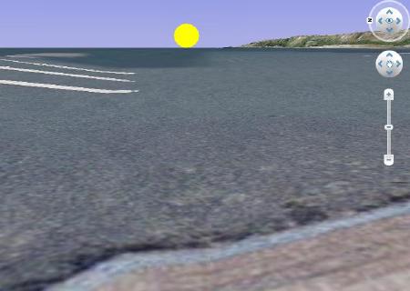
Port Angeles Eastern Horizon. Map created by howderfamily.com using Google Earth

Here I’ve attempted to recreate a similar scene from the Port Angeles city dock using Google Earth. This image faces directly towards the eastern horizon at eye-level with 3D turned on. I’ve added the sun just south of east to approximate the date of the Flickr photo, March 6. From this I can deduce that while the headland is visible to the right, the shoreline plain forming Dungeness Bay must be below the horizon. Otherwise the sun would rise over it.

We can speculate that sunrise over water would definitely occur between the vernal equinox (late March) and the autumnal equinox (late September) for sure, plus probably another month on either end. Theoretically the situation should only improve as one moves further along the top of Olympic Peninsula towards the Pacific Ocean since it takes a decidedly northwestern slant after Port Angeles.


California

I could find only one other spot along the coast where I positively identified a sunrise over water. That happens in the Channel Islands off of southern California. The mountains behind Los Angeles appeared in the preponderance of on-line photographs from Catalina Island and its primary town, Avalon. However I did find an example on Flickr. I think it’s probable that it occurs only during certain parts of the year. The angles need to line up just right, similar to what we discovered on the Olympic Peninsula.

Indeed west coast sunrises happen over water. However, they are extremely rare compared to their reverse counterparts on the east coast. This was a fun entry to compile and I particularly enjoyed the group effort. If anyone has other topics to explore, please feel free to post them and we’ll start the discussion again.

Comments

16 responses to “West Coast Sunrises over Water”

  1. […] Twelve Mile Circle » Blog Archive » West Coast Sunrises over Water […]

  2. Matthew Avatar

    Just thought I’d send my belated thanks for your research on the west coast sunrise question that I posed a few weeks ago. I think we do have very similar interests with respect to geographical quirks. We live in WA state and we’re now planning a summer trip that will involve Port Angeles so we can see the west coast sunrise over water firsthand (I also have a strong desire to check out the 45 X 90 spot in Poniatowski, which I discovered on your site and then blogged on my own site some time ago, but that’s another story).

    Here is another idea for you in the event that you’re looking for future blog entry ideas: time zone boundaries. My favorite location is about 22 miles south of Grangeville, Idaho. Check it out. There is a strange boundary there where, when you travel east to cross a time zone boundary, you actually move from Mountain Time to Pacific Time. Typically, when we move east we move later in the day, but in this case when moving east it gets earlier. Kind of fun. Anyway, many thanks again for your great blog, of which I’m a big fan. All the best – Matthew

    1. Twelve Mile Circle Avatar

      Matthew, this was one of the funnest entries I’ve put together so the research was definitely part of the enjoyment!

      I do indeed get a kick out of strange time zones, and the example you provided is a good one that I’d like to check out someday. Yes, that’s something I’d drive at least a couple hours out of the way to visit, for sure. The strangest time zone I’ve visited personally is the whole Arizona vs. Navajo vs. Hopi conundrum I describe in my regular website, "What Time is it in Arizona?" I haven’t made it yet to the tiny Navajo exclave of Jeddito surrounded by Hopi territory for the full effect, but that’s on the list too.

      Do let me know if you succeed in documenting that west coast sunrise over water and I’ll be sure to update this post. Also, if you make it to the 45X90 spot be sure to visit the nearby Wisconsin Highpoint in the same trip. The actual 45X90 spot is a little underwhelming but the Highpoint is rather scenic I couldn’t find the 45X90 reference on your website. Would you be kind enough to post a link in a comment, below?

  3. Matthew Avatar

    The link is below. As you can see, I borrowed your images for this entry and tried to follow your terms and conditions for image use. There is also a link to a song written about Poniatowski, which is kind of cute and will probably get stuck in your head for days. It happened to me, so beware.

    http://weblog.xanga.com/prullmw/653163267/concept-travel-destination-15-the-center-of-the-northern-half-of-the-western-hemisphere.html

    1. Twelve Mile Circle Avatar

      That’s a great post. I’ve run across that ditty before too with the same unfortunate result. No problem with the borrowed images. Actually, you did me even one better than the Terms and Conditions. You copied them over and you provided a link back, so zero bandwidth impact. Thanks! You’d be surprised (or perhaps you wouldn’t) with the number of people who never even think about that. I had to do a photo switcheroo on someone just within the last day who was sucking bandwidth from my Alaskan Brewery page.

  4. Mathew Hargreaves Avatar
    Mathew Hargreaves

    I came across this little website area about 2 years ago and have been considering again working to get the photo. I am assuming that by definition the disc of the sun must be on the edge of the water. In that case, the previous Port Angeles shot is too high. Not to mention that there is Canadian land mass hidden behind the clouds under the sun. I know the spot where the photo was taken and I do not take it as definitive for your purposes. There is not enough water curvature at this place.

    Two years ago I studied the problem with a map and drove out to one area that has a land mass extending out into the Strait and feel this is the only decent potential spot for the photo. I had always planned it for a summer shot but this might be an error due to humidity blocking the view that is wanted. However, had I remembered the photo idea during winter and reread this site, a shot on a cold clear morning might be the best opportunity. But any wind chill factor at the shooting point would be a serious issue for the body and the camera. I now have a medium format digital Pentax camera. In July they will be selling a GPS unit for this camera and that would a be a great time to go for the image.

    Since the idea is back on the burner of my brain, I am going to drive out to the place and talk to the locals about the weather conditions during the year. I need to plan for the proper exposure for a single shot and for a wide panoramic view.

    CHEERS…Mathew – Port Angeles.

    1. Twelve Mile Circle Avatar

      This sounds like a great adventure. I will keep my fingers crossed and hope for your success. I’d love know the lat/long coordinates of such a spot, as it may be the only one outside of Alaska.

    2. Lance Gillette Avatar
      Lance Gillette

      Hello From Rasmuson Library, University of Alaska Fairbanks:

      I am creating a catalog record for your book: “Research notes: regarding the digital reincarnation of vanadium …”

      There is a performer with your name that was part of a music CD in 1995. We need to differentiate you from him by adding your full middle name or your year of birth.

      Give me a call at (Nine-Zero-Seven) Four Seven Four Seven Two Zero Six.

  5. Mathew Hargreaves Avatar
    Mathew Hargreaves

    Sorry for the delay in answering. I have been very busy getting the last of the photos I can take of the Elwha river dams. They are closed down now but the gates are locked as of July 1. I have shot a lot of panoramas and they take a lot of time to process. In fact, the day I was going out to the coast to check the area out never happened. An event at the lower dam forced me to shoot there and at the other dam all day. I am hoping to get it done real soon though as it will make a great shot if I can get it.

    BTW, I am in Port Angeles. Where are you?

    CHEERS…Mathew

    1. Twelve Mile Circle Avatar

      The other Washington. Well, just across the river from it anyway… Arlington, VA.

  6. Fritz Keppler Avatar
    Fritz Keppler

    This might be cheating a little bit, but one time in late November 1993 while on a train trip along the West Coast, I stopped in Oakland and rented a car, driving it as far as Gaviota, CA on US 101 before returning northward by a different route (this was before I was intentionally collecting crossing county lines), sightseeing and visiting various California missions. I was on the road well before sunrise one morning (not difficult because of the lateness of the sunrise so far west in that time zone), and got to the ocean and parked at an overlook to watch the sun come up. It was of course pretty far south because of the lateness in the year, and the coast at that point runs almost due east-west. It was neat to watch the sun rising over the Pacific Ocean! I got some analog video of it, but it doesn’t digitize very easily.

  7. Mathew Hargreaves Avatar
    Mathew Hargreaves

    Sorry for the long delay. Last week I went to the shooting sight and found it socked in with fog. On September 8, I was again there and got the sunrise shots but the sun was over the Canadian landmass. From all of the images I took I was able to calculate the timeframe window to take the photo. What matters is will the weather cooperate.

    After I took the shots on the 8th I would have not thought it impossible. But rethinking the issues involved show it to be possible.

    CHEERS…Mathew

  8. Mathew Hargreaves Avatar
    Mathew Hargreaves

    On the 19th I got one or two passable shots. The issue is fog. It is partially covering the sun but both upper and lower edges of the disc help to define its presence and location on the water. The window of opportunity is a very narrow window of about ten days. Before this the sun will rise on the Canadian landmass, and after rising on the Straights of Juan DeFuca it will rise on the American landmass. I may try again on Tuesday the 20th. Rain is expected on Wednesday and Thursday. After that Friday may be the last chance for the year.

    I should mention it is a 100 mile round trip each time I do this. After all the work I can answere with a definate yes that a sunrise on water on the West Coast is possible. An interesting academic idea that you guys proposed.

    CHEERS…Mathew

    1. Twelve Mile Circle Avatar

      Matthew, you should get a medal for going above-and-beyond to prove this. Tuesday, September 20, 2011, may go down in the history books of geo-oddities on the Twelve Mile Circle!

  9. Mathew Hargreaves Avatar
    Mathew Hargreaves

    Yeeha!

    I have them. Today, September 20, with a sunrise at 7:01. The shots were taken at Sekiu on the west side of Clallam Bay. Specific location is on the beach at the northwest end of the protective jetty.

    The fog was gone and the view was spectacular. There were large container ships moving through and all the local fishermen were zipping out like a cloud of mosquitos. Just when the top edge of the sun rose above the horizon, one of the large container ships started across it. Nooooo! I said. But luckily it cleared as the sun rose higher. Then the fully charged battery failed! Lots of &$%^#&&*$(#( followed as I struggled to get the backup battery loaded in seconds. Then the shots started rolling in. I also took three or four too in Infrared but have not looked at them yet. I hastely shots some three panel shots for stitching that will show the land masses on each side. Since none of the objects in any of the sequences have still objects the automated stitcher cannot assemble them. They will have to be built by hand.

    If I owned a 300mm lens for my Pentax 645D the shots would have been wonderful.

    Send me an email at my home email address.

    CHEERS…Mathew

  10. Juliana Avatar
    Juliana

    I went to India to the Kanyakumari, place where you can see the sunrise and sunset on the ocean.Do you know how many degres are between them, my kid told this amazing story to his geography teacher and she said there is not such a thing that you can see the sunrise and sunset over the ocean frim the same spot. I think that they told us that is was within 10degrees of difference. Is there a website or a place where my son can find more info to enlighten his peers and teacher?

Leave a Reply

Your email address will not be published. Required fields are marked *

Latest Comments

  1. I am in La Libertad, El Salvador. Was absolutely astonished to see the sun rise at one end of the…

  2. Thank you for this information. I was searching “closest distance between towns of opposite elevations” and reveals zero results, at…

  3. I agree with a two mile run with admission proceeds go to the local Hancock schools in maryland doing it…

  4. Rock Springs Campmeeting is not the only one in NC. There’s also Balls Creek Campground, McKenzie’s Grove, and Mott’s Grove;…