Winneconne seems so much like many typical villages I’ve experienced during my travels through the Upper Midwest of the United States, at least on the surface. Farming and fishing commingle along beautiful lakes carved into the landscape by glaciation during the last Ice Age. It’s what makes Wisconsin one of my favorite places on earth to visit during the warmer months of the year.
Winneconne conforms to that expectation. It sits strategically along the Wolf River between Lake Poygan/Lake Winneconne and Lake Butte des Morts, which then flows into the much larger Lake Winnebago. Anglers flock to the area for its abundance of walleye and bass. In turn, these fishermen help balance local economies otherwise dependent on agriculture.
However, Winneconne and its 2,500 residents once seceded from the United States and declared independence. They never expected this tongue-in-cheek gesture to be taken seriously. Nonetheless, it underscored an issue of great significance to a village that valued tourism dollars.
Erased from View
The Sovereign State of Winneconne website focuses on the situation and its commemoration. It started when the State Highway Commission inadvertently deleted Winneconne from its official state highway map for 1967. An historical overview traced the initial awareness to an article in the Winneconne News,
“Guess what? Would you believe that the village of Winneconne is no more? The state map makers must have been napping when they should have been mapping – they completely eliminated the village from the new Wisconsin road maps. They were gracious enough to leave the dot where Winneconne used to be, but the name was lost somewhere between Omro and Butte des Morts.”
The local Chamber of Commerce, justifiably concerned that fishermen wouldn’t be able to find the town, wrote a letter to the Governor. The state replied and acknowledged an innocent error. It would be corrected in the 1968 map or perhaps earlier if they needed to reprint the 1967 map. The state couldn’t pull-back a million copies already printed. That sounds pretty reasonable, doesn’t it?
Then a Milwaukee newspaper picked up the story and it went national.
The fine citizens of Winneconne decided to have a little fun with the situation and their newfound attention. It predated a more famous tongue-in-cheek secession that also leveraged the news media, the Conch Republic, by a good fifteen years.
Independence Declared
Winneconne established a committee — labeled the “secret” committee as part of the gag — to discuss their options. They held a contest to determine their response. The winning entry proposed secession from the United States. This beat an alternate proposal that would have pursued annexation to another state, preferably one with better weather.

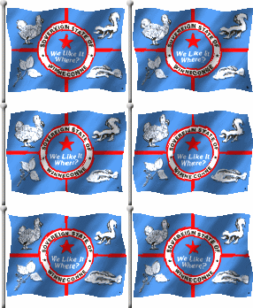
Winneconne declared its independence on July 21, 1967, with their Village President installed as king. Their flag included its national symbols.
- Dodo (official bird)
- Skunk (official Animal)
- Poison Ivy (official flower — didn’t know poison ivy flowered until I Googled it just now)
- Fish (maybe a bass?)
Flags of the World included a larger version if you’d like to see it in greater detail including its motto, “We Like It — Where?”
Further background information can be found in “Declarations of Independence: Encyclopedia of American Autonomous and Secessionist Movements,” by James L. Erwin:
I didn’t realize one could embed a page from Google Books in a website, so I’ve learned two new things today. Also, oddly, the dates don’t match exactly with the history on the Sovereign State website.
The Rebellion Ends
Wisconsin “capitulated” by promising to put up a road sign, place Winneconne brochures at state rest stops, fix the map in future print runs and various other conciliatory gestures. The brief secession ended at 12:01 p.m that same day.
The Winneconne Area Chamber of Commerce notes the contribution of this happenstance to putting the town on the map literally and figuratively:
“It could be called the greatest thing to ever happen to Winneconne… what might have been a disaster was turned into the greatest publicity stunt in the history of the area…we were able to bring our governor, our congressional representative and a good part of the country to join in the fun. Dozens of people were part of that busy summer of 1967, and dozens more have contributed a great deal of time and effort in the years since…”
Notably, Winneconne holds an annual Sovereign State Days festival each July featuring three days of activities and a parade. Their 44th annual celebration took place this year, 2011.
Bonus
One fact has been left unmentioned, which I discovered only as I examined a map of Winneconne in further detail. None of the several histories, accounts or descriptions that I researched describes this geo-oddity. Feel free to consider this a Twelve Mile Circle exclusive, a little something extra that other sources either failed to discern or considered insignificant:
Had the Sovereign State of Winneconne retained its independence (yes, I know — humor me) then it would have included a small enclave of the United States within its borders. This empty field would be a U.S. outpost completely surrounded by foreign territory. This plot is a doughnut hole in an otherwise contiguous village.

Leave a Reply