Each Twelve Mile Circle journey has its own specific objectives. The western North Carolina adventure focused heavily on the burgeoning craft brewing scene. Collectively they also share common objectives, principally the pursuit of geo-oddities along with opportunities to pad my county counting totals.

I thought I did well. I adding eighteen new counties with fourteen of them found in North Carolina and four in Virginia. In North Carolina I captured Alexander, Alleghany, Ashe, Avery, Caldwell, Jackson, Mitchell, Rutherford, Swain, Transylvania, Watauga, Wilkes, Yadkin and Yancey. The Virginia counties were Grayson, Floyd, Franklin and Patrick.
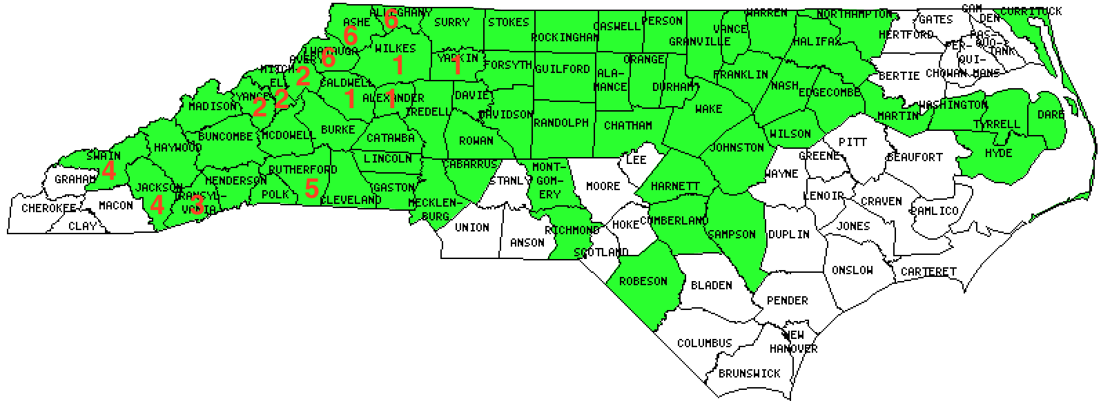
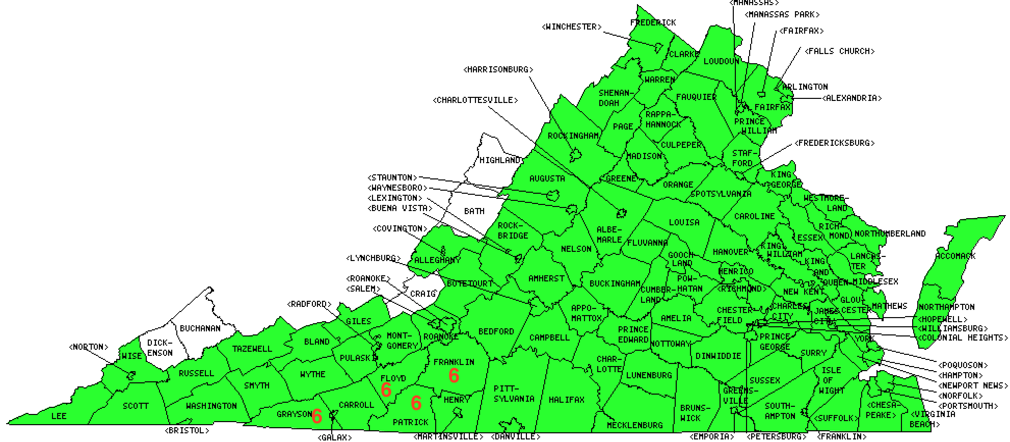
These visits happened in six separate efforts, some of them requiring significant forethought and others pleasantly simple. I’ve numbered the efforts in chronological order and noted them on the maps below. Is shows how I added counties sequentially throughout the trip. This labeling exercise also summarized the journey rather nicely and served as a solid bookend for this final article in the series.
North Carolina was the primary focus so I’ll begin there.

(1) Chapel Hill to Asheville
The logical path would have involved Interstate 85 from Chapel Hill and then Interstate 40 onward toward Asheville. That would have made perfect sense if I’d been trying to minimize driving time. It made no sense for this exercise. I’d already captured all of the interstate counties so it didn’t pay to repeat them.
Instead I devised several intermediary jogs that took my path through the towns of Winston-Salem, Wilksboro, Taylorsville and Lenoir. That slightly jagged track yielded new four counties: Yadkin; Wilkes; Alexander and Caldwell. I lost surprisingly little time on this track too, maybe less than an hour.
(2) Blue Ridge Parkway Loop
The wonderful Blue Ridge Parkway day-trip that included a a cave, a waterfall, the highest point of elevation in North Carolina, and a restaurant placed atop a county tripoint also netted three new counties. I captured Avery, Mitchell and Yancey that day.
(3) Oskar Blues
I mentioned before that Oskar Blues made my brewery visit list because it happened to be located in Transylvania County. I wondered if it had any connection to the Transylvania in Romania? You know, the alleged home of vampires and other scary creatures? Well, it didn’t.
They both derived their names coincidentally from a couple of very common Latin words, trans (“across”) and silva (“woods”). Thus, any place named Transylvania was merely something located beyond a forest. That certainly described western North Carolina a couple of centuries ago when the Transylvania Company tried to form a colony in that unforgiving part of the wilderness.
“The Transylvania Company was organized as Louisa Company in 1774 to invest in vacant, nonpatented wild lands within the chartered limits of North Carolina and Virginia. In the fall of that year, Captain Nathaniel Hart visited the Overhill Cherokees at their Otari towns to negotiate for the lease or purchase of an immense tract of land between the Kentucky and Cumberland Rivers… Transylvania Company’s so-called purchase from the Indians was publicly denounced by the governors of Virginia and North Carolina, however, and the scheme was invalidated.”
The Transylvania name lived-on when Transylvania County formed much later on some of the same land, in 1861.
(4) Cherokee Loop
We had another entertaining day on the Cherokee Loop. That track that took us onto the lands of the Eastern Band of the Cherokee Nation. Then we proceeded onward to Great Smoky Mountains National Park and the highest point of elevation in Tennessee. It also netted Jackson and Swain Counties.
(5) Lake Lure & Chimney Rock
I admitted a couple of days ago that I’d orchestrated a day trip to Lake Lure and Chimney Rock simply to capture Rutherford County, and fill a doughnut hole on my map. It was worth a stop regardless.
(6) Asheville, NC to Roanoke, VA
Returning home, once again the logical path would have involved the Interstate Highway System, specifically I-26 and I-81 here. However I had to capture a number of quite obscure rural counties. So this became the most ambitious county counting adventure of the trip. It involved a complicated series of intermediary waypoints on the eastern edge of the Blue Ridge including two short out-and-back detours designed to prevent doughnut holes.

Just as we left Mouth of Wilson, Virginia on a double-back to capture Alleghany County, North Carolina — the photo at the top of the page (map) — my younger son announced he needed to pee. Immediately. We were in the middle of nowhere, miles from the nearest facilities of any kind, and on a mission. Nonetheless, being the good father that I am, I pulled over to the side of the road and scouted a suitable tree to shield his act of desperation. That’s when I noticed I was standing within a patch of poison ivy. I grabbed a water bottle from the car and washed off furiously. Then I sped to the nearest gas station bathroom where I scrubbed my legs with soap and water repeatedly. I escaped mostly unharmed and chalked it up as another hazard of County Counting.
Don’t worry about the kid, he found a more suitable tree minus the poison ivy.
Those four new Virginia counties in an out-of-the-way corner left me within striking distance of finishing the Commonwealth. Virginia is notoriously difficult to complete because it has 95 counties plus 38 independent cities that are considered county-equivalents. That’s a total of 133 separate units that must be visited. I have five remaining in a fairly straight path. I figure I can knock-out the rest of Virginia in a weekend and I plan to do so within the next few months.

Leave a Reply