Carolinian Canada? I know the Carolinas (North and South) and I’ve visited parts of Canada, but I’d never seen the two combined before into a single thought. I’d spied that unfamiliar phrase during my exhaustive search for the world’s best place to observe a sunrise and a sunset over water. Naturally it triggered my curiosity. I felt compelled to decipher that odd juxtaposition of geographic notions. Could I find a connection between the two notions? What might it entail?
My earlier search had already led me across the jagged coastlines of many nations before I arrived at a spot on Point Pelee National Park in southwestern Ontario. One can’t go any far south on mainland Canada. It’s surprisingly southern, maybe even strikingly southern. This area extends farther south than much of the United States, includes parts of California. I am not exaggerating. However, as impressive as it is, it does not extend as far south as the Carolinas.
Lake Effect

Nonetheless, Parks Canada described Point Pelee as being located with the Carolinian Zone and that’s where I first encountered the phrase:
“The plants and animals of Canada’s Carolinian zone are found only in a narrow band. The northern boundary of this band follows the 8°C (46°F) isotherm (that is a line which defines an area in which the average daily temperature for the year is 8°C). Temperature, then, is a major factor in limiting the northward expansion of this unusual region.”
“Intrusion of the 8°C isotherm into Canada at this point is the result of two major factors. The first is geographical position. Southwestern Ontario extends south to the 42nd parallel, making it the southernmost tip of Canada. This contributes to its warmer climate, but ‘lake effect’ is even more important. Southwestern Ontario is almost completely surrounded by the Great Lakes. Large bodies of water like this are hard to heat and, once heated, are slow to cool. Consequently, they tend to cushion temperature peaks cutting off the high and low extremes.”
More Like Parts of the United States
Uncharacteristically for Canada, the Carolinian Zone features broad-leafed deciduous forests of hickory, sassafras, oak, walnut, ash, birch, tulip trees and various other hardwoods. Few conifers intrude upon this space. More biodiversity exists here than in any other Canadian climate area. It even provides habitat for the nation’s only lizard species, the five-lined skink (Hey, I’ve photographed one of those before… but it wasn’t in Canada). Opossums, raccoons and flying squirrels frequent this area in great abundance.
This all sounds very familiar to me personally and it should. The same set of physical characteristics extend deep into parts of the United States. There they call it the Eastern Deciduous Forest. In the USA, it’s an expansive zone stretching from the Carolinas (aha!) westerly towards the Mississippi River, up through the Appalachian Mountains and right onto the doorstep of Canada where it just barely manages to extend across the border. Thus Canada’s Carolinian Zone — including its name — has much more in common with the climatic conditions of a large swath of the eastern United States than it does to the rest of Canada.
In the Zone

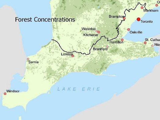
The Carolinian Zone covers less than one-quarter of one percent of Canada’s landmass. That’s practically nothing when compared to the nation’s size overall. It encompasses the area located below the black dividing line on the map displayed above.
However, most Canadians live close to the southern border and it’s particularly true here. Notice the metropolitan areas encapsulated within this zone. They include Toronto, Hamilton, Niagara, London, and Windsor. Quite remarkably, about twenty five percent of all Canadians live and work within the tiny confines of the Carolinian Zone.
This presents a dilemma. Very little original deciduous forest remains except in small, isolated pockets like Point Pelee National Park. Farmland and growing metropolitan areas encroach on the residual and ever-dwindling biodiversity. Even so, some people understand that trend. They hope to preserve the remainder of this shrinking habitat before it disappears.
Carolinian Canada, for example, is a ” non-profit coalition of over 40 government and non-government conservation groups and many individuals working to conserve the ecological diversity of Canada’s most threatened natural region.” They’ve initiated projects that melds conservation science with mapping technology. Thus, they hope to connect isolated habitat areas with green corridors to allow movement between them. Carolinian Canada serve as a focal point for bringing together varied conservation efforts into one cohesive response.
They have quite an uphill climb ahead of them in this unique corner of Canada, this little echo of the distant Carolinas, so fragile and threatened.

Leave a Reply