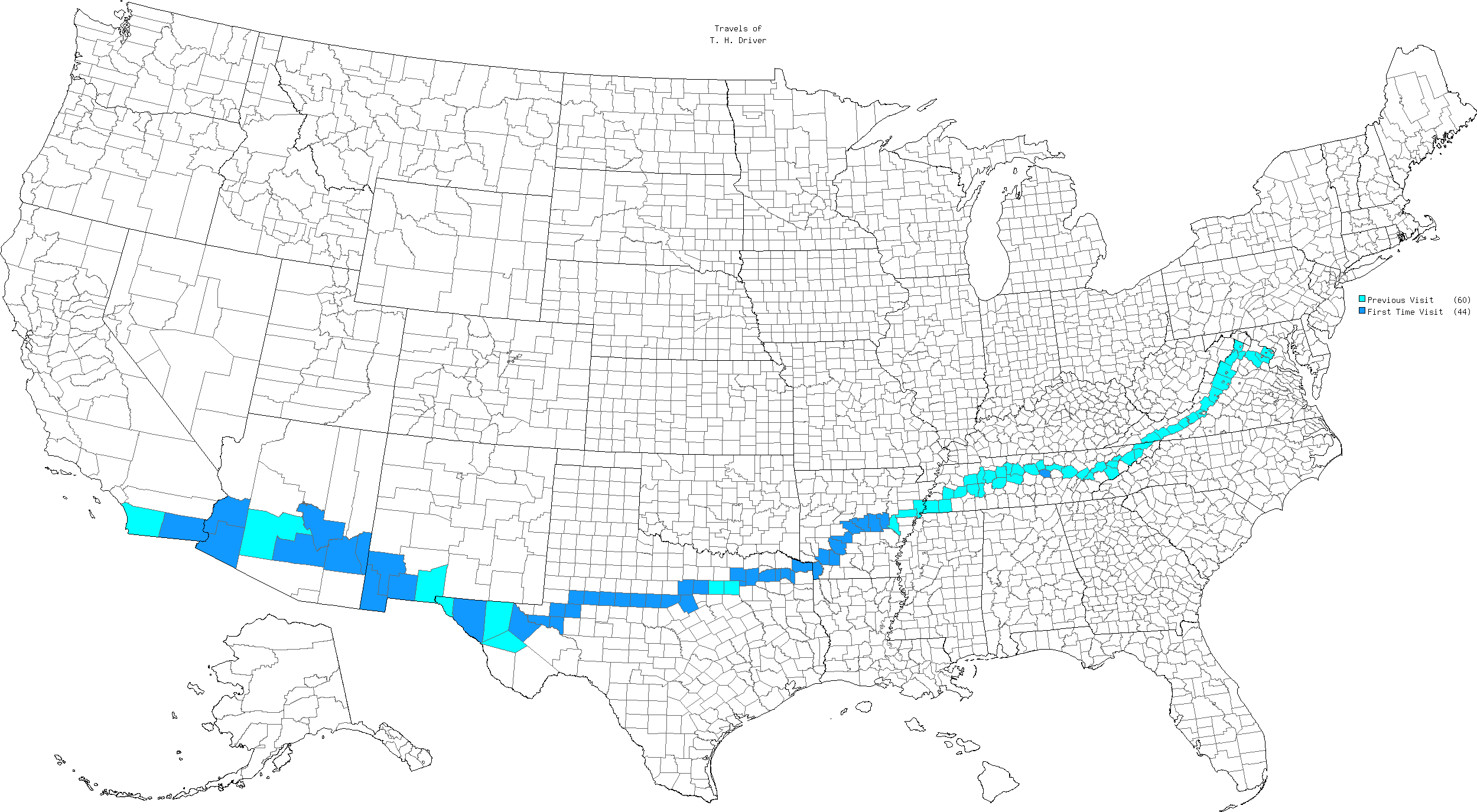
I wanted to grab some new counties.
That basic objective served as a guidepost, the unifying premise for the entire trip. We would see other things along the route and during most of a week in Phoenix, Arizona, of course. However, make no mistake, I wanted the new counties more than anything else. As noted earlier, the middle-southern route offered the best opportunity for the most unclaimed counties during our limited time. It looked pretty nice on a map too.
Overview

This route crossed through 104 counties on its nationwide path. I’d captured 60 of them in previous drives (light blue). The other 44 joined my personal lifetime list as brand new additions (dark blue). Interstate highways cut a direct path, with plenty of easy captures. I also scheduled a handful of jogs, a reroute and an out-and-back to pad the total a little more.
Feel free to click on the map to see a larger image in another tab.
Jogs
I selected two jogs during the journey. I defined a jog as an incidental out-and-back. Ideally a jog should add only a few minutes to the overall drive time. The easiest jog happened on Day 2 in Tennessee. Interstate 40 passed a half-mile north of DeKalb County with a convenient exit at the optimal spot (map). This capture took maybe two minutes and represented the only new capture during the eastern third of the trip. My son took it all in stride and didn’t even raise an eyebrow. He knew the deal.
The Collin County, Texas capture on Day 3 should have been equally convenient. However, construction blocked the exit we needed. Then Interstate 30 took a decidedly southern tack, moving it farther away from Collin.
We took the very next exit into the little community of Royce City and guessed at at the easiest route up to Collin Co. We headed northeast and felt vindicated as we crossed County Line Road. My son actually seemed to enjoy that mini-adventure and the educated orienteering necessary to complete it.
Reroute
I decided to forego Interstate 10 as we approached Arizona, preferring to take a parallel route on much smaller U.S. Route 70 instead. This marked our only significant departure from the Interstate highway system. It added an hour to the overall length of our drive although the reroute allowed us to capture three out-of-the-way counties; Greenlee, Graham and Gila.
The highway rolled through rugged, empty landscape. We entered Duncan, one of only two towns in Greenlee County. Barely a handful of people lived there and intuition told me that I shouldn’t drive even a single mile per hour above the posted speed limit. Sure enough, the sheriff sat right behind the 25 mph sign and I passed without incident. I didn’t see much else in Greenlee County although apparently one of the largest copper mines in the world existed there. The mine employed 4,000 people, or about half of the county population.
Later I drove through Safford in Graham County, a much larger town than I expected in such a remote area. Several adjacent towns hugged the same stretch of highway, accentuating the population. This seemed to be the only sizable community anywhere along Route 70, with a bunch of traffic lights that all seemed to be red as we approached and about every major box store imaginable.
Out-and-Back
We arrived in Phoenix as expected and poked around for several days from the rental house we used as our base. I’ll talk about that in a future episode. However, I still hadn’t stopped counting. My map showed a blank space on Interstate 10 due west of Phoenix, representing the County of La Paz.
On Sunday morning, I woke up early and drove for an hour on an empty freeway to a nondescript interchange, then looped back to Phoenix. The entire adventure lasted about two hours and I spent less than five minutes in La Paz. It still counted. This would be significant a couple of days later. Shockingly, nobody else in the family wanted to join me.
By the way, this wasn’t the farthest I’ve gone on an out-and-back. That honor probably went to Elko County, Nevada during my Utah trip a few years ago. Altogether that one took about four hours.
Bonus Counties
Phoenix was our intended destination from the start. Even so, it began to gnaw on me that we’d come so close to driving across the country without actually reaching the Pacific. I enticed my zoo-loving son with the ultimate prize, a chance to visit the world famous San Diego Zoo. So we added an overnight trip to San Diego onto the tail end of our Arizona adventure. That also allowed me to capture Yuma Co., Arizona and Imperial Co., California. With Yuma, I finished all of the Arizona counties, my first completed state west of the Mississippi River.
Articles in the Cross-Country Series:
- The Plot Thickens
- Weatherford Art Thou?
- County Counting
- Zoos & Brews
- The Eastern Half
- The Western Half
- A Week in Phoenix
- Bonus!
See Also: The Complete Photo Album on Flickr

Leave a Reply